
3D Maps
3D Maps is a paid add-on that adds an interactive 3D map of your venue to your screens — hotels, shopping centers, campuses, trade fairs, hospitals — with points of interest and step-by-step routes. Visitors navigate the map from the screen or from their phone, and you design it yourself, with no technicians required.
It is an optional add-on: it's contracted separately from your device plan. You can even have it without any device contracted.
Price and trial
- 10-day free trial when you activate it.
- After that, €49/month charged to your saved card. Cancel whenever you like.
- The charge is aligned with the billing day of your device subscription (or the 27th if you have no devices), prorating the first month so everything is charged on the same day.
Activate the add-on
- In the side menu, open Add-ons → 3D Maps.
- You'll see the presentation page with the add-on details. Click Start 10-day trial.
- Choose the card for the charge (or click Add card if you don't have one saved yet) and confirm with Accept and start the trial.
- The add-on is active instantly. Nothing is charged during the trial; the first charge is made when the 10 days end.
If you cancel at any point, the button changes to Reactivate 3D Maps.
Create and edit maps
With the add-on active, Add-ons → 3D Maps shows the list of your maps:
- New map — create a map for a venue.
- Search — find a map by name.
- On each map: Edit (opens the visual editor) and View map (previews it as the visitor will see it).
The first time, you'll see "You haven't added any maps yet" — click New map to get started.
The visual editor
The editor lets you build the map with no technical knowledge:
- Photo mode — trace the buildings over an aerial photo or a plan of your venue.
- Colors by category — automatic or custom.
- Move and rotate entire groups of buildings, and import/export the complete map.
- Points of interest (POI) — link each building to its point of interest.
- Step-by-step routes to any point of interest.
- Multi-language and mobile-friendly.
Any change you save is published immediately to your screens.
Show the map on a screen
The 3D map is a web URL like any other content source: assign it to the screen as a web URL (kiosk) or within a playlist. See Kiosk settings and Playlists.
The map on a large screen
On screens wider than a phone (totems, TVs) the venue menu, with the search box and the categories, is always visible: it has no X and does not fold into the menu button, so nobody is left with a tiny button on a big screen. On medium-sized screens, while a route is being followed, the card shrinks to a bar; tap it to open it again. On phones the menu folds away as before.
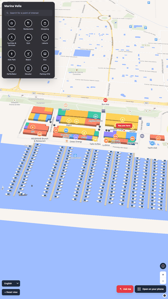
- So that the screen knows which totem it is (its You are here point and the start of routes), add
?kiosk=<totem slug>to the map URL. In the editor, the Kiosks list shows each one's slug and a link to its view. - After about 90 seconds without use, the totem returns to the initial view and closes routes, windows and the assistant.
The viewer needs a modern browser (Chrome or WebView 111 or later). Old Android screens with an older WebView (for example Android 5 with WebView 60) cannot show the map.
Open on your phone
The Open on your phone button, bottom right and always visible, shows a QR code. When scanned, the phone opens the same map in the same language, with the point of interest that was on screen and, if a route was showing, the route from the totem. The QR window closes by itself after 60 seconds.
Video on a point of interest
In the editor, each point of interest has a Video field below Photo. The video is shown in the point's card instead of the photo.
- Formats: MP4 (H.264) or WebM, up to 50 MB, 5 minutes and 1920 × 1080. HEVC/H.265 videos (the usual iPhone format) and AV1 are refused: export them as MP4 H.264 ("Most compatible"). Up to 500 MB of video per venue.
- Options: With sound (off by default), Play when the place is opened (on) and Loop (on). Remove deletes the video.
- Save the point before adding a video to it. On upload, the file's metadata, such as the GPS location, is removed.
- If the browser does not allow playing with sound, the video starts muted and shows a hint to tap to hear it.
- In low-power mode the video does not start by itself: the image is shown and it plays when tapped.
No audio (screens without speakers)
Under Venue, the No audio (screens without speakers) box makes every video play muted with no sound button, even if it has With sound. It applies to phones and the web, and to the totems that inherit it. Under Kiosks, each totem can inherit the venue's setting, force Yes: videos always muted, no sound button or state No: this totem has speakers.
AI assistant
The Ask me button opens a chat with suggested questions (for example Vegan options, Where are the toilets?, Something for kids or Where can I eat quickly?) and, if you allow it, questions typed by the visitor. It answers only from that map's points (name, category, description, tags and hours), never invents places, and every result has Show route to start the route from the totem.
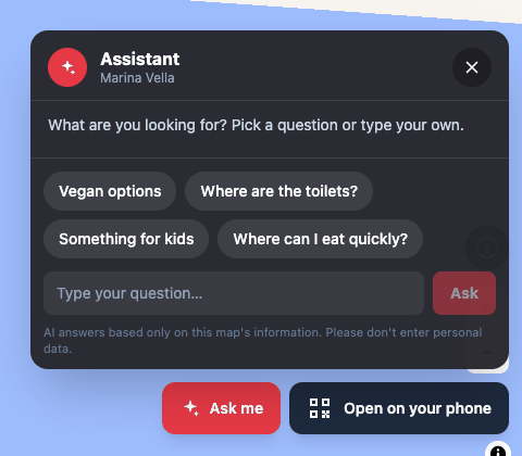
It is off by default. To switch it on, in the editor, Venue section, AI assistant card:
- Tick Enabled on this map.
- Optional: Allow typed questions, Max AI requests per day (300 by default, up to 1,000) and the Suggested questions (up to 8, in each language: Add question, Remove, Restore the defaults).
- Press Save.
For better answers, fill in the points' descriptions and hours, and use each point's Tags (for the AI assistant, comma-separated) field (for example vegan, gluten-free). Tags are not shown on the map.
- It answers in the visitor's language. Each question stands alone, and closing the panel or the idle reset forgets the conversation.
- Answers to suggested questions are stored, so most of them use no AI requests. The card shows today's usage.
- Typed questions are never stored, only counted. The panel reminds visitors not to enter personal data.
Low-power mode
On modest hardware the map switches to a low-power mode by itself: the route is not animated, decorative 3D models are not loaded, it draws at a lower resolution and videos do not start by themselves. It switches on when the device has 2 GB of memory or less, 2 cores or less, a basic GPU or no WebGL2. You can force it by adding ?lowpower=1 to the map URL, or turn it off with ?lowpower=0.
Cancel
You can cancel from the same add-on page. Cancellation takes effect at the end of the period: you keep access and your maps until the renewal date, and you won't be charged again. You can reactivate before that date so you don't lose anything.
Frequently asked questions
Do I need devices to use 3D Maps? No. You can contract the add-on on its own; the map is served by URL and you can open it from any screen or phone.
Who can edit the maps? Any user with access to the company that has the add-on active.
Are the maps lost if I cancel? You keep access until the end of the paid period. By reactivating before that date, you don't lose anything.